![]()
Download site for DIF maps of the Iberian Peninsula
The solar radiation maps on this website are raster layers with a resolution of 100 m, in UTM-30N projection with the ETRS89 datum. They contain solar radiation data for the Iberian Peninsula and are available in two formats:
- MiraMon: .img in .mmzx (ISO 19165:2018), openable directly in MiraMon.
- GeoTIFF: .tif in .zip (ISO/IEC 21320-1:2015), openable in various environments after downloading the ZIP.
The DIF (diffuse solar radiation) contribution, used for calculating the InsolMets model, is estimated as a ratio to direct solar radiation, attenuated by atmospheric scattering under clear sky conditions (τ0=0.288), neglecting terrain effects and shadows, using DIF data observed at different meteorological stations (DIFvsDHI). The estimation also includes solar vector incidence angles, considering the Sun's position every 30' from sunrise to sunset. These calculations are performed with the InsolDia application within the free MiraMon GIS software. The results are expressed as percentages.
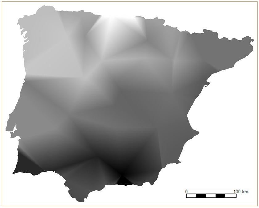
DIFvsDHI (Dec 2001–2020)
The data on this website have been prepared by Catalina Roca-Fernández, Xavier Pons and Miquel Ninyerola, from the Grumets research group at the Universitat Autònoma de Barcelona, as part of a comparative study of methods for calculating solar radiation in the Iberian Peninsula, published in:
➠ Roca-Fernández, C.; Pons, X.; Ninyerola, M. (2025). "A Comparison of Different Solar Radiation Models in the Iberian Peninsula". Atmosphere, 16(5), 590. Doi: 10.3390/atmos16050590
⟹ DIFFUSE SOLAR RADIATION NETWORK
- The DIF network used for calculating the DIFvsDHI parameter is available at: Solar radiation network AEMET-Spain
- The meteorological stations from the AEMET-Spain network are available at:
https://www.infoambiental.grumets.cat/RadSolarPI/Networks/SolarRadNet_AEMET_Spain.zip (.csv in .zip)
https://www.infoambiental.grumets.cat/RadSolarPI/Networks/SolarRadNet_AEMET_Spain_ETRS89.mmzx (.pnt in .mmzx)
https://www.infoambiental.grumets.cat/RadSolarPI/Networks/SolarRadNet_AEMET_Spain_WGS84.mmzx (.pnt in .mmzx)
* To request solar radiation data from the AEMET-Spain network, please contact: Services AEMET-Spain
The integration of DIF data observed at meteorological stations has been published in:
➠ Roca-Fernández, C.; Ninyerola, M.; Pons, X. (2024). "Diagnosis for integrating the main Iberian networks of solar radiation meteorological stations". GeoFocus, 33, pp. 43-75. Doi: 10.21138/GF.850
*****
DIF layers are available in different formats
- Monthly climate data: 12 layers (one per month), providing median values for that month over the entire 2001–2020 period.
- Global data: 1 layer for the entire period, providing median values (2001–2020).
➢ Monthly climate data (2001–2020):
➢ Global data (2001–2020):
| MiraMon format (.img in .mmzx) | GeoTIFF format (.tif in .zip) |
|---|---|
| https://www.infoambiental.grumets.cat/RadSolarPI/DIF/DIFvsDHI_2001_2020.mmzx | https://www.infoambiental.grumets.cat/RadSolarPI/DIF/DIFvsDHI_2001_2020.zip |
For any questions you can write to Xavier.Pons@uab.cat